I love legible city wayfinding, such as those well-designed systems that can be seen in London and Bristol, and I am quite often delighted to see artistic interventions in our urban landscapes. Being the type of designer that enjoys a playful twist on the ‘norm’ I have often spoke about the idea of mixing the two – wayfinding and art – to create something more exploratory, where maybe the term wayfaring is more applicable. Of course it needs to be done in the right place for the right reason, and when it can be, I see it as an opportunity to create a placemaking narrative – to tell a story – to create interventions that would be surprising, fun and informative.
An intelligent approach that could bring meaning through place narrative, heritage and the contemporary with landscape mapping, trail-making and wayfinding would, I believe, create a unique place experience that would generate intrigue, become a ‘talking-point’ and literally put a place ‘on-the-things-to-see’ map.
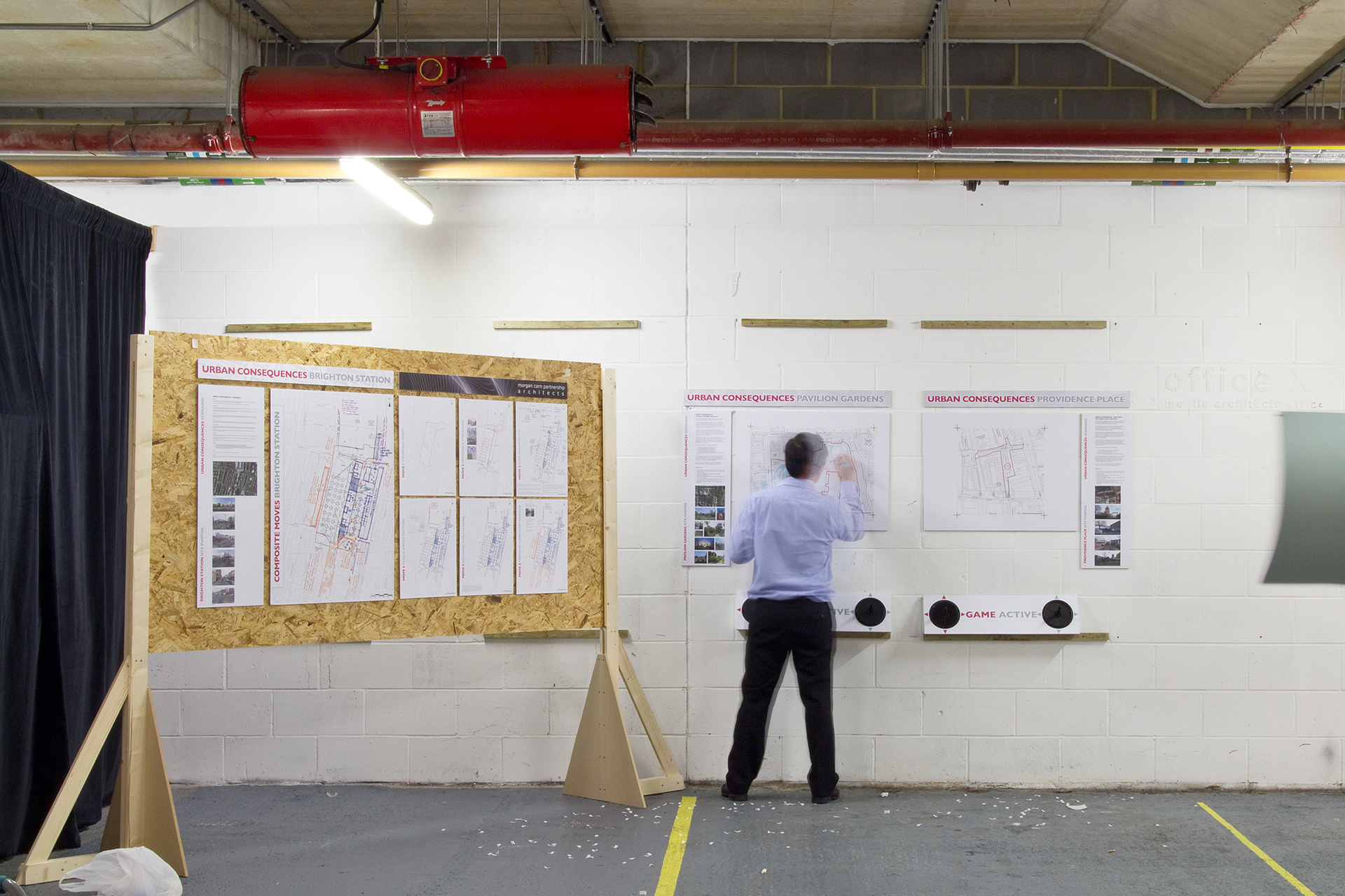
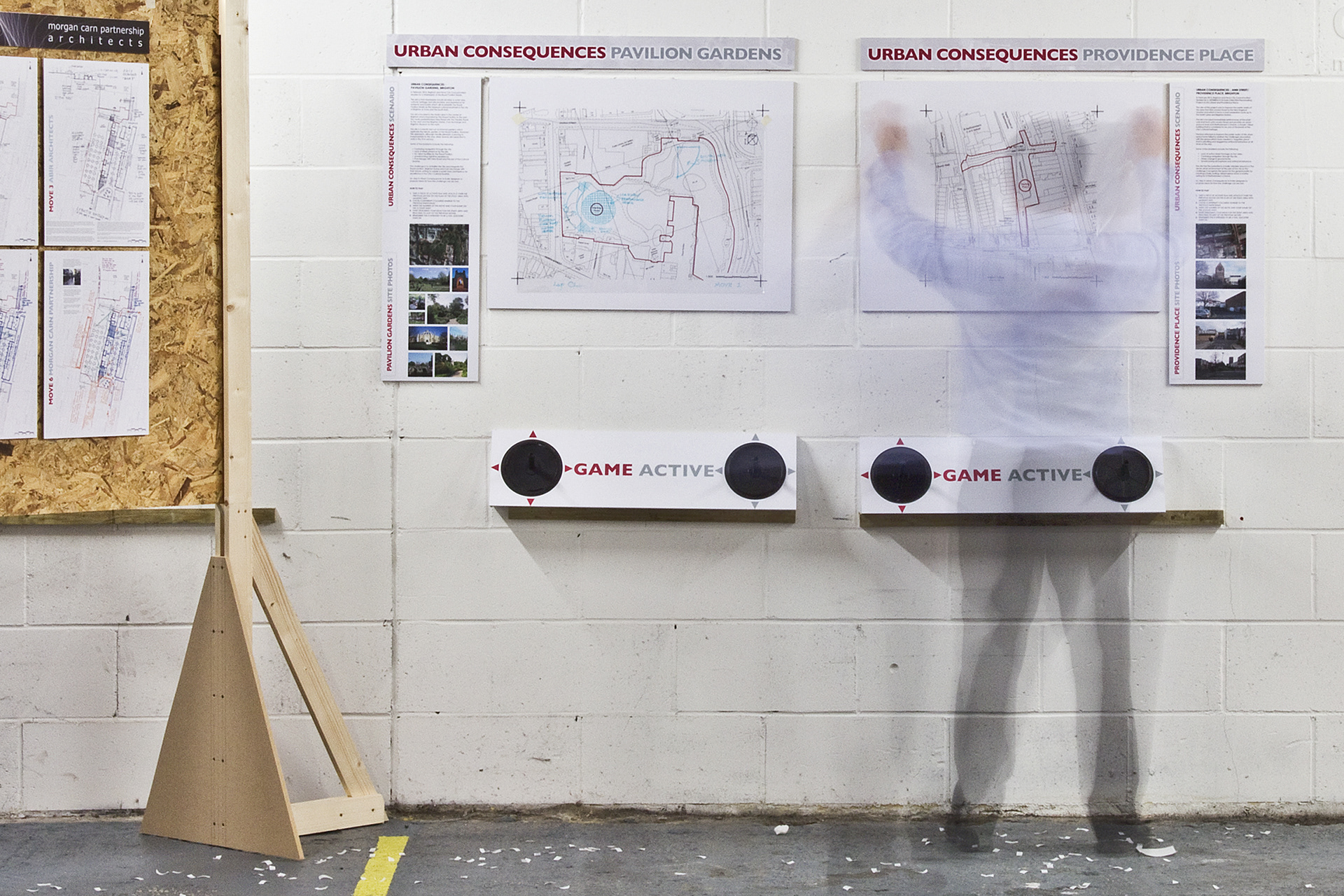
A couple of years back I got to explore this idea when invited by Lap Chan at Morgan Carn to get involved in his Urban Consequences project for a Love Architecture Festival. Urban Consequenceswas theoretical architectural and design ‘game’ and Lap invited a number of architects and designers to look at how we could, without constraint, develop the arrival space immediately outside Brighton Station.
I took the view that an artistic and informative arrival experience would create a welcoming and engaging space as visitors arrived in the city. I called my idea As the gull flies – a design embedded into the walkway surfaces where seagull silhouettes (our ‘native’ bird and football team symbol) and place locations are mapped to create a directional flow out of the station. As the gull flies is a parody of ‘as the crow flies‘ where Brighton landmarks are listed and laid in what seems a series of chaotic directions, although are, in fact, pointing in the direction as the gull flies – embedded into the surfaces to create a directional ‘map’. The size of the font is indicative of how far away the place is – the bigger the lettering, the closer the place, the smaller the lettering the further away it is. The design doesn’t give precise distances or acts like a traditional map, but is designed to encourage exploration and an engaged place experience. The directional lettering is supported by the gull illustrations ‘flying’ in the same direction. The laying out of the texts also emulates driftwood that ends up on the beach and a decorative font which is expressive, with movement and an element of fun.
Although the Urban Consequences project was a theoretical exercise and was designed to initiate a dialogue, it was also an opportunity for me to explore my idea of wayfaring placemaking narrative – an idea that I’m looking to explore further in our urban and landscape environments.
The full story of Urban Consequences, the idea and how each design move unfolded is described below.
(The following transcript from Lap Chan)
The Seed
When John Barradell became Chief Executive of Brighton & Hove City Council in October 2009 one of his first announcements was his desire to improve Brighton’s ‘welcome’ by creating a gateway to the city in front of Brighton Station. He is quoted as saying ‘At present when you walk out of the station you really don’t see the best of Brighton and Hove’.
When John Barradell became Chief Executive of Brighton & Hove City Council in October 2009 one of his first announcements was his desire to improve Brighton’s ‘welcome’ by creating a gateway to the city in front of Brighton Station. He is quoted as saying ‘At present when you walk out of the station you really don’t see the best of Brighton and Hove’.
The Germination
This quote was the kernel that evolved into an idea of how to create an interactive process that, unhindered by the usual commercial constraints, could be used to gather ideas about how the public realm can be improved. This idea gradually evolved into Urban Consequences, a forum that will allow the imagination to run riot, to think the unthinkable and result in an ambitious vision of the kind of city we could have and should aspire to live in.
This quote was the kernel that evolved into an idea of how to create an interactive process that, unhindered by the usual commercial constraints, could be used to gather ideas about how the public realm can be improved. This idea gradually evolved into Urban Consequences, a forum that will allow the imagination to run riot, to think the unthinkable and result in an ambitious vision of the kind of city we could have and should aspire to live in.
The Aims
Based on the childhood game of consequences urban consequences will hopefully demonstrate through a series of reactive interventions how, once freed from the constraint of things like different site ownerships we can arrive at a collaborative vision of the kind of urban spaces that the participants aspire to create.
Based on the childhood game of consequences urban consequences will hopefully demonstrate through a series of reactive interventions how, once freed from the constraint of things like different site ownerships we can arrive at a collaborative vision of the kind of urban spaces that the participants aspire to create.
The site
The study area for this first game of Urban Consequences will start immediately in front of Brighton Station and could, depending on the move of each participant, concentrate on that original area or gradually move in any direction as long as one edge touches an edge of the last move.
The study area for this first game of Urban Consequences will start immediately in front of Brighton Station and could, depending on the move of each participant, concentrate on that original area or gradually move in any direction as long as one edge touches an edge of the last move.
The scenario at the time
At the time the area immediately in front of Brighton Station is a confusing mass of taxis and buses with no sense or arrival or welcome to the city. There is little given to the pedestrian who has to run the gauntlet of avoiding the traffic, negotiating barriers and being herded onto narrow pavements. The worst thing is, this is many visitors first impression of the city and happens at the head of the vista down to the sea. If ever there was an invitation for an urban set piece this is it.
At the time the area immediately in front of Brighton Station is a confusing mass of taxis and buses with no sense or arrival or welcome to the city. There is little given to the pedestrian who has to run the gauntlet of avoiding the traffic, negotiating barriers and being herded onto narrow pavements. The worst thing is, this is many visitors first impression of the city and happens at the head of the vista down to the sea. If ever there was an invitation for an urban set piece this is it.
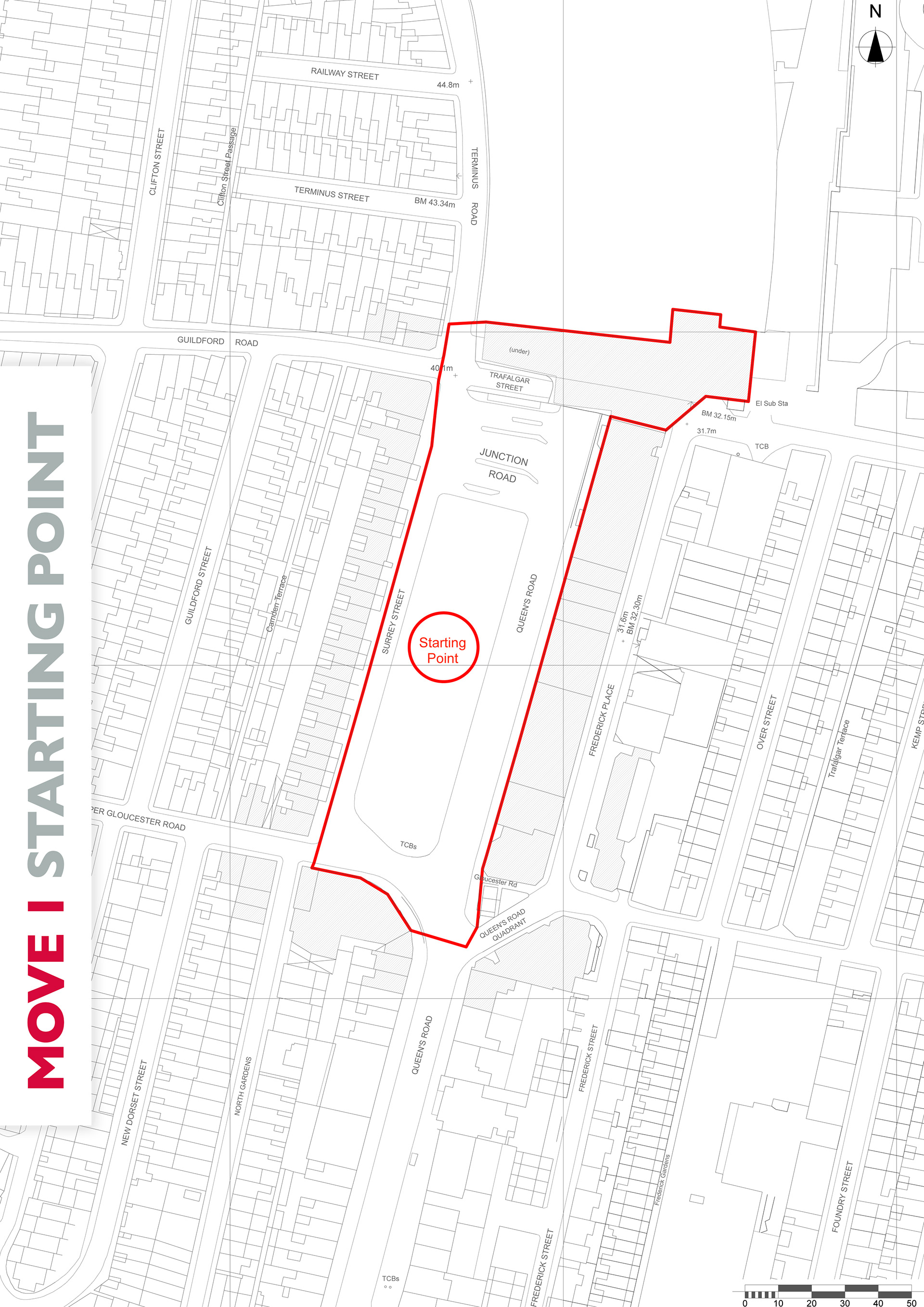
The First Move
The first move of the game has been to remove the existing buildings on the island site that is bounded by the station to the north, Queen’s road to the east and Surrey Street to the west. This leaves a void in the urban fabric. An invitation to react to the opportunity to change the ‘gateway’ to Brighton and present a vision of the kind of city we should aspire to live in. The participant is free to choose whether to fill the void, enhance it, leave it untouched… in fact almost anything.
The first move of the game has been to remove the existing buildings on the island site that is bounded by the station to the north, Queen’s road to the east and Surrey Street to the west. This leaves a void in the urban fabric. An invitation to react to the opportunity to change the ‘gateway’ to Brighton and present a vision of the kind of city we should aspire to live in. The participant is free to choose whether to fill the void, enhance it, leave it untouched… in fact almost anything.
Summary
At the end of the game, the various moves will be amalgamated into a cohesive urban design proposal which will be publicised on the website and press.
At the end of the game, the various moves will be amalgamated into a cohesive urban design proposal which will be publicised on the website and press.
The moves (as described by each participant)
The first move is in red, which cleared the island of buildings outside the station.
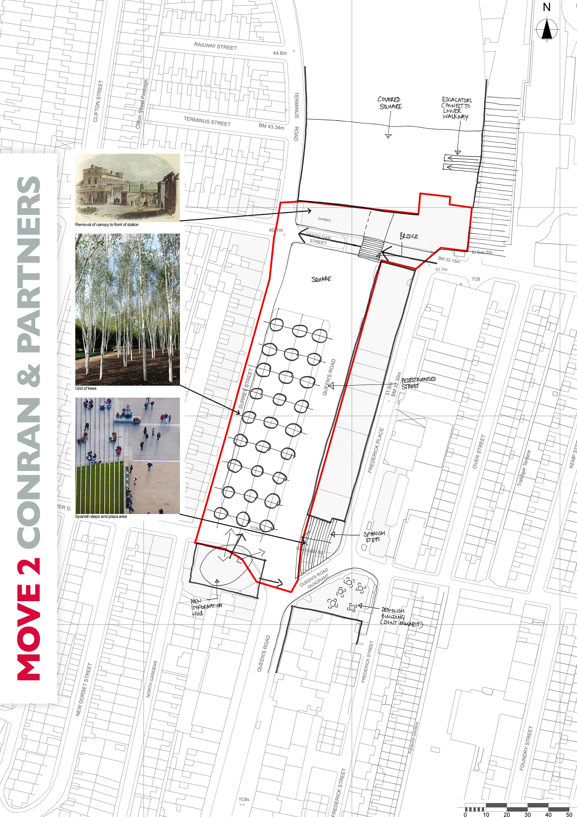
The second move was by Conran+Partners (in black)
The station forecourt has been opened up by removing the canopy to the front which reveals the view to the east of St Peter’s Church. A bridge over Trafalgar Street connects the station to the new square and pedestrianised Queen’s Road with a grid of trees to the west. Buses use Surrey Street and taxis use Frederick Place accessed from the station via the escalators to the lower level. The lower level also connects to the north of the station site. A new information hub, removal of the corner buildings on Queen’s Road Quadrant and introduction of Spanish steps makes this a focal point with direction to the sea, North Laines and the station.
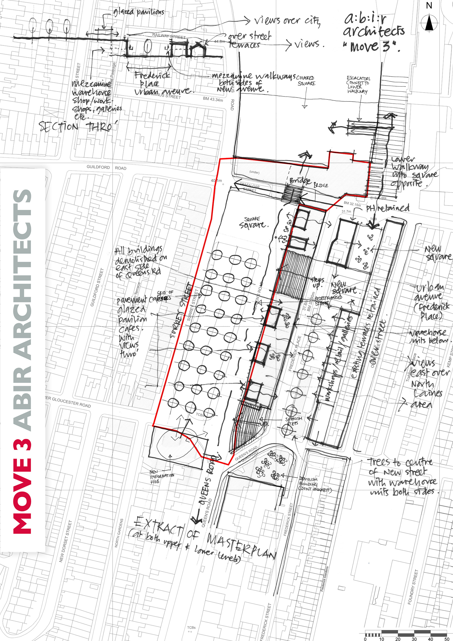
The third move was by A:B:I:R (in blue)
Retaining the majority of the proposal established by Conran in Move 2 outside the station with bridge, new square and pedestrianised Queens Road with a grid of trees, ABIR architects have chosen to inhabit the city block to the south-east of the station connecting the upper Queens Road level and lower Frederick Place level, thus creating a vertical connection across the site and beyond. We acknowledge that connections south to the seafront and north to the New England Quarter and beyond are fundamental and we hope would form a revitalised connection south. However the introduction of a secondary focus east-west is also of considerable importance and will create an urban pedestrian block linking to the upper Queens Road proposal that occupies and inhabits adjacent to the main route from the station to the seafront.
Removal of all buildings outside the station create an upper open edge to the square overlooking a lower urban avenue in the position of Frederick Place. The removal of these buildings will provide a clear setting and open edge to the square punctuated by a series of glazed pavilions and street cafes lining the east side of the new treed route thus opening up views across the north laines and connecting the city further to the east. A second set of (Spanish) steps from Queens Road to Frederick Place are introduced connecting with a lower smaller square in place of the both the set back offices in Frederick Place and the Thrifty car garage in Trafalgar Street.
Frederick Place, a pedestrianised lower level, is lined with trees through the centre (mirroring the upper grid) with both sides being inhabited with new double height retail, workshops, galleries, retail, cafes etc where the existing buildings are removed. The Albert Pub is retained and acts as an elbow between the main upper square and lower squares and connecting the end of the new walkway (proposed in Move 2) to the new England Quarter and an enlivened public space at the top of Trafalgar Street. The newly pedestrianised Frederick Place turns into Frederick Street via the open space at Queens Road quadrant proposed in Move 2. Traffic must be secondary to this vibrant urban pedestrian block and routes north – south with taxis and buses occupying edges further out from their current pickup and drop off areas.
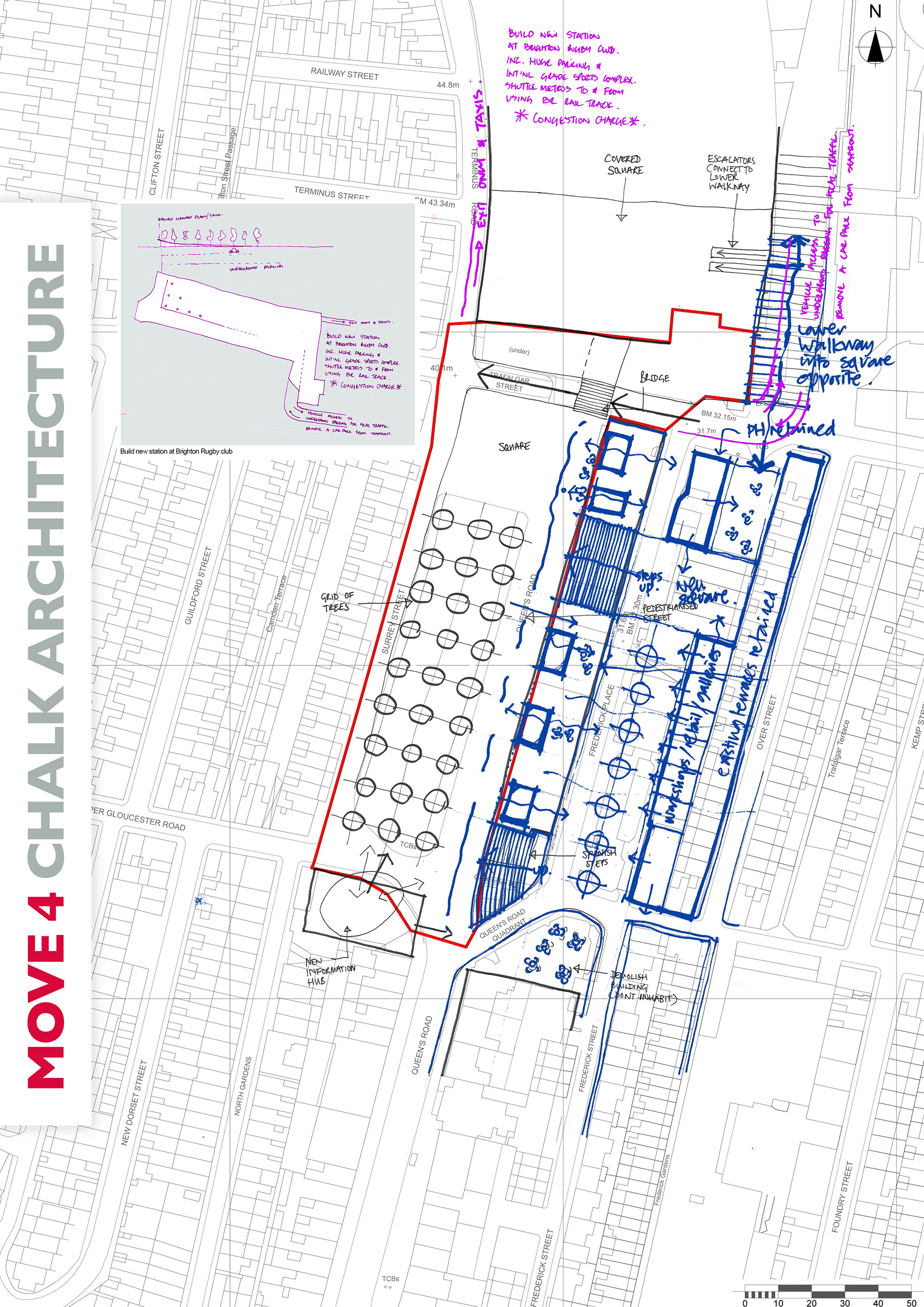
The fourth move was by Chalk (in Purple)
The move involved building a new station at Brighton Rugby Club including huge parking and an international grade sports complex. Shuttle metros will run to and from the sports complex using British Rail Rail Track. A congestion charge will be bought in to the centre of Brighton. Underground parking will be installed under the existing station with vehicle access on a ramp to the side, leading to one of the sea front car parks being removed.
The move involved building a new station at Brighton Rugby Club including huge parking and an international grade sports complex. Shuttle metros will run to and from the sports complex using British Rail Rail Track. A congestion charge will be bought in to the centre of Brighton. Underground parking will be installed under the existing station with vehicle access on a ramp to the side, leading to one of the sea front car parks being removed.
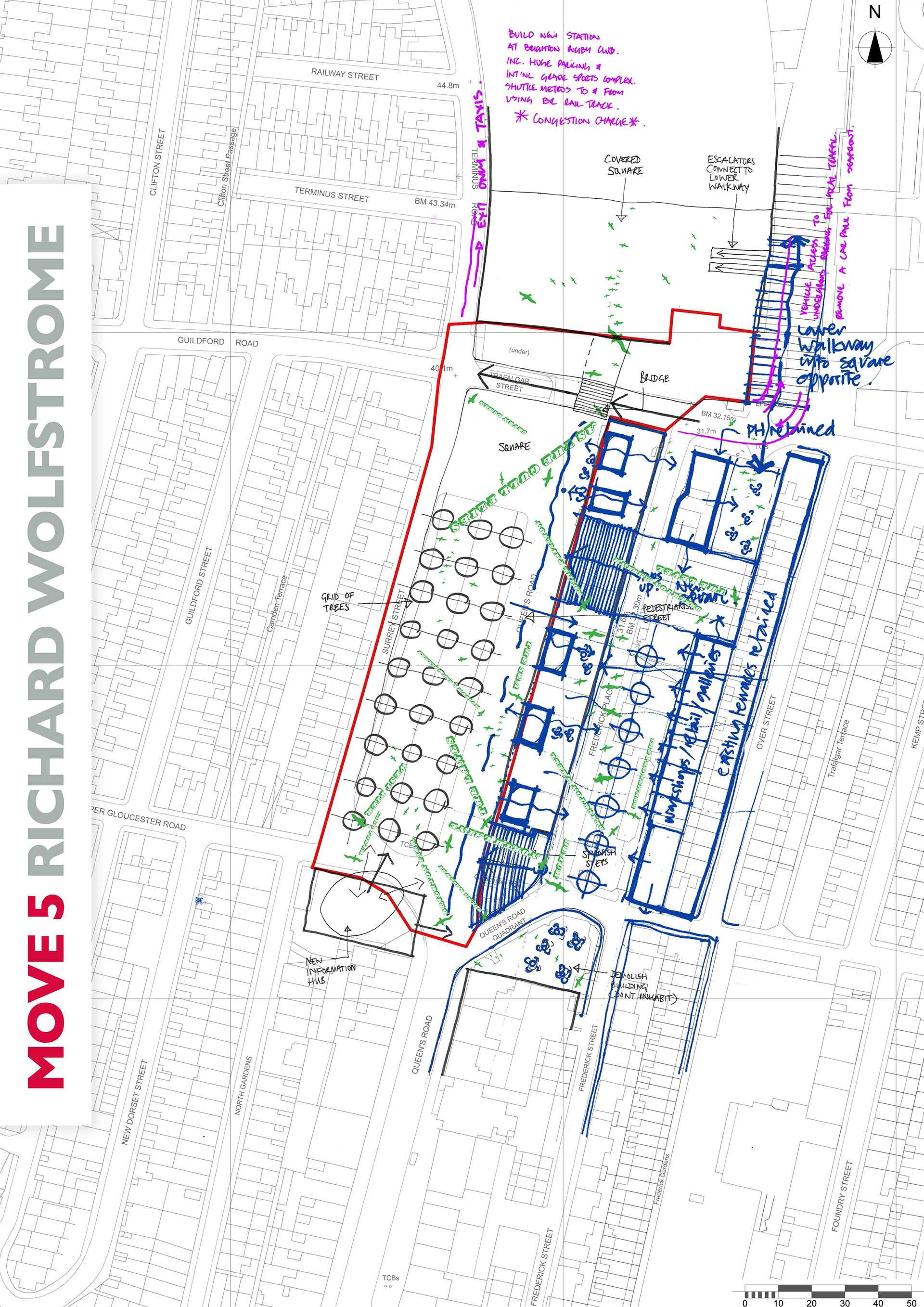
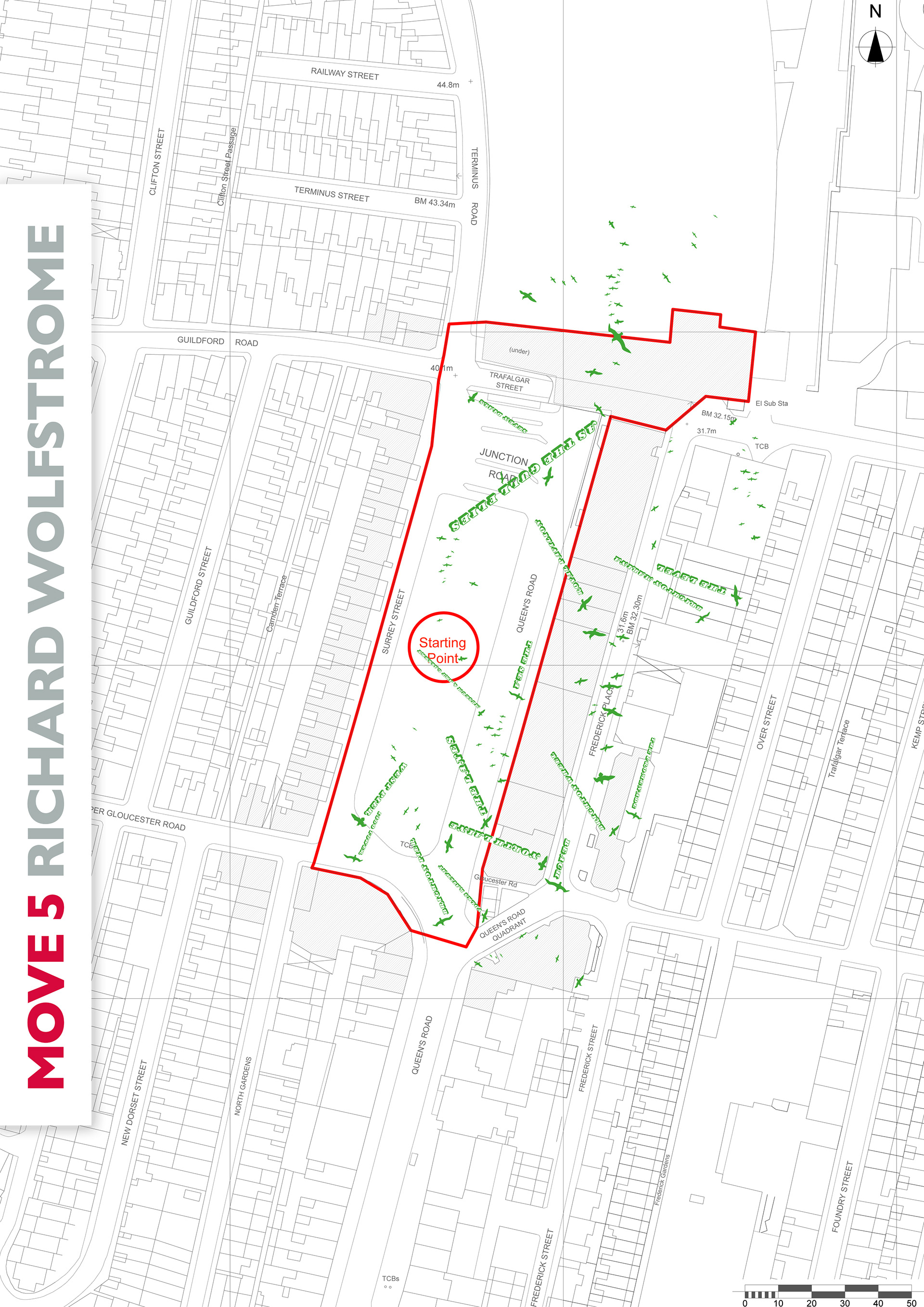
The fifth move by Richard Wolfstrome (in Green)
As the gull flies – a design embedded into the walkway surfaces where seagull silhouettes (our ‘native’ bird and football team symbol) and place locations are mapped to create a directional flow out of the station. As the gull flies is a parody of ‘as the crow flies‘ where Brighton landmarks are listed and laid in what seems a series of chaotic directions, although are, in fact, pointing in the direction as the gull flies – embedded into the surfaces to create a directional ‘map’. The size of the font is indicative of how far away the place is – the bigger the lettering, the closer the place, the smaller the lettering the further away it is. The design doesn’t give precise distances or acts like a traditional map, but is designed to encourage exploration and an engaged place experience. The directional lettering is supported by the gull illustrations ‘flying’ in the same direction. The laying out of the texts also emulates driftwood that ends up on the beach and a decorative font which is expressive, with movement and an element of fun.
As the gull flies – a design embedded into the walkway surfaces where seagull silhouettes (our ‘native’ bird and football team symbol) and place locations are mapped to create a directional flow out of the station. As the gull flies is a parody of ‘as the crow flies‘ where Brighton landmarks are listed and laid in what seems a series of chaotic directions, although are, in fact, pointing in the direction as the gull flies – embedded into the surfaces to create a directional ‘map’. The size of the font is indicative of how far away the place is – the bigger the lettering, the closer the place, the smaller the lettering the further away it is. The design doesn’t give precise distances or acts like a traditional map, but is designed to encourage exploration and an engaged place experience. The directional lettering is supported by the gull illustrations ‘flying’ in the same direction. The laying out of the texts also emulates driftwood that ends up on the beach and a decorative font which is expressive, with movement and an element of fun.
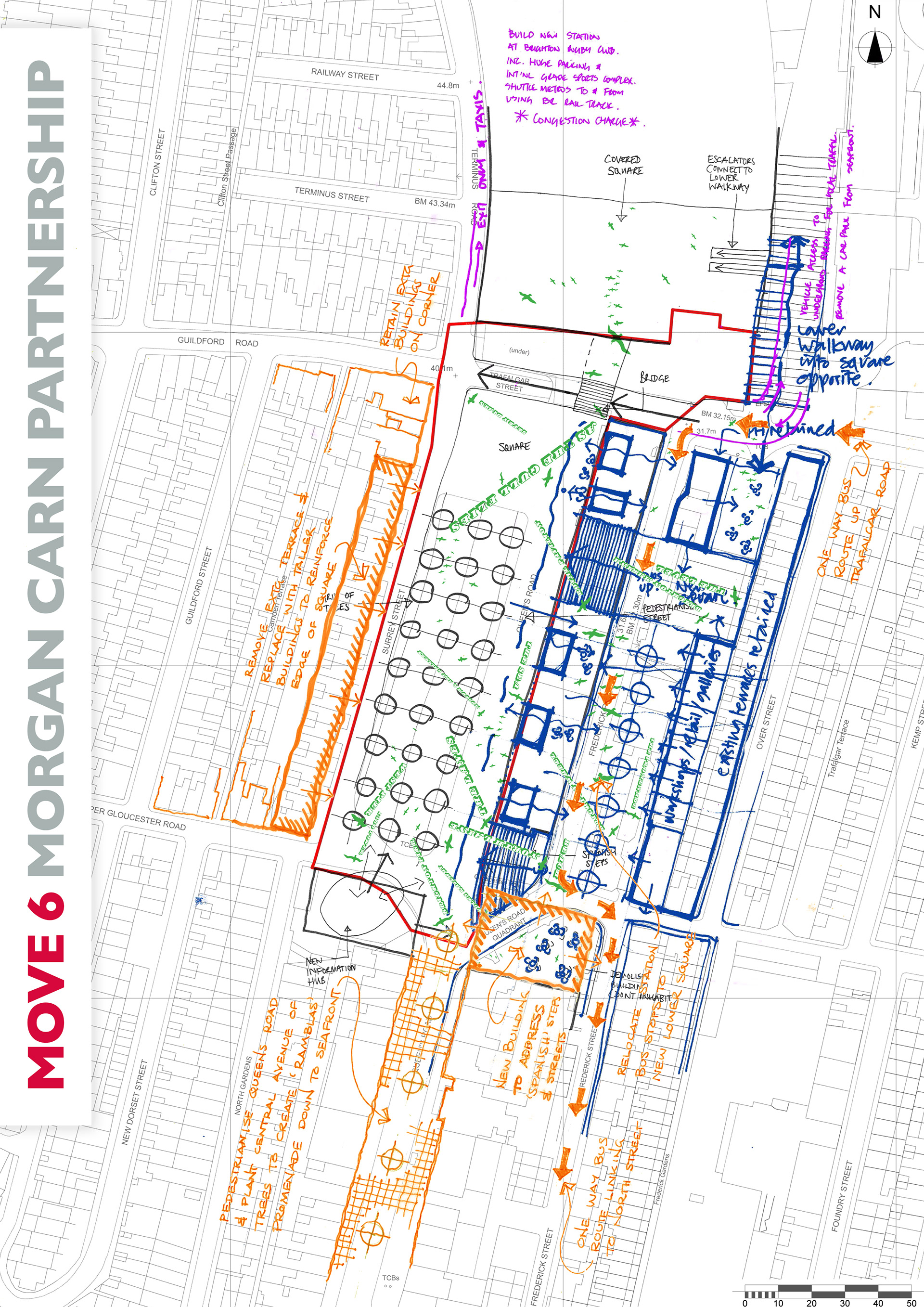
The sixth move was by Morgan Carn Partnership Architects (in Orange)
Proposes a series of actions to enhance the environment of the new station square and extend the experience south along Queens Road to create a ‘Las Ramblas’ style promenade which will link the station to the seafront. The actions include the following:
Proposes a series of actions to enhance the environment of the new station square and extend the experience south along Queens Road to create a ‘Las Ramblas’ style promenade which will link the station to the seafront. The actions include the following:
• Reinforce the western edge of the new station square by removing the existing terrace and replacing it with taller buildings which will be appropriate to the scale of the square.
• Pedestrianise Queens Road and plant a central row of plane trees to create a promenade space similar to ‘Las Ramblas’ in Barcelona.
• New replacement building to address proposed ‘Spanish steps’ and lower square.
• Relocate station bus stops to lower square and introduce new one way bus route parallel to Queens Road.